
MIT’s Treepedia Maps Urban Tree Canopy In Major Cities
MIT’s Treepedia reveals where the streets are greenest, and which ones could use more work.
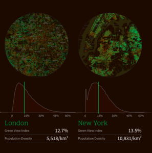
Which cities have the greenest streets? MIT’s Senseable City Lab is pushing toward an answer to this question with a new project called Treepedia. A map website that catalogues the density of the tree canopy in 10 global cities, Treepedia uses information from Google Street View to create what it calls the Green View Index—a rating that quantifies how green a street view looks according to the number of trees it contains.
-
March 2, 2024
Firefighters rush to subdue deadly Panhandle wildfire before dangerous conditions return Saturday -
February 14, 2024
Texas Workforce Commission presents Texas Conference for Employers -
February 1, 2023
Are your trees damaged by the ice storm? -
July 28, 2022
Another benefit of Texas trees: Cooler temperatures -
February 25, 2022
Time to Plant Trees in Texas -
January 27, 2022
Treemergency: Mulch Volcanos are Erupting in Landscapes! -
December 21, 2021
Cedar fever season in Texas -
November 9, 2021
Texans celebrate 2021 Arbor Day in Weatherford, Texas – and beyond -
June 24, 2021
41st Texas Tree Conference, Academy, Trade Show and Tree Schools -
February 17, 2021
Texas Sized Winter Storms Can Damage Trees
Submit an Article